dryfj.com / drycyclist.com (kevin cook)

5559/7119
Home /

Rounding "the big curve" on Kelbaker Road, I begin the 10-mile home stretch toward Baker

07419-kelbaker-road-curve-800px.jpg Round-trip hiking route from Mid Hills campground to Thomas Place, Live Oak Spring and "Seep Canyon" (Day 8)ThumbnailsRoute 66 closely parallels the I-40 freeway the rest of the way to Ludlow, my destination todayRound-trip hiking route from Mid Hills campground to Thomas Place, Live Oak Spring and "Seep Canyon" (Day 8)ThumbnailsRoute 66 closely parallels the I-40 freeway the rest of the way to Ludlow, my destination todayRound-trip hiking route from Mid Hills campground to Thomas Place, Live Oak Spring and "Seep Canyon" (Day 8)ThumbnailsRoute 66 closely parallels the I-40 freeway the rest of the way to Ludlow, my destination todayRound-trip hiking route from Mid Hills campground to Thomas Place, Live Oak Spring and "Seep Canyon" (Day 8)ThumbnailsRoute 66 closely parallels the I-40 freeway the rest of the way to Ludlow, my destination todayRound-trip hiking route from Mid Hills campground to Thomas Place, Live Oak Spring and "Seep Canyon" (Day 8)ThumbnailsRoute 66 closely parallels the I-40 freeway the rest of the way to Ludlow, my destination today

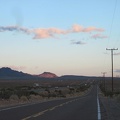
I've exited the hilly areas into the glory of open-desert sunset light.

Baker is over in front of those mountains ahead. Even though this road drops another 1000 feet between here and there, it looks pretty flat as it rolls out across the desert floor.