dryfj.com / drycyclist.com (kevin cook)

8/74
Home / Mojave Preserve and Desert bikepacking trips / 2009, Fall: Mojave National Preserve / Day 7: Bull Canyon hike, Granite Mountains, Mojave National Preserve /

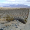
Heading down the other side of the power-line road is almost as steep as it was coming up

07866-powerline-road.jpg Looking back down the power-line road hill that I just walked up, toward the Providence MountainsThumbnailsA GPS check tells me that I can turn left anywhere here and start hiking up the fan to the mouth of Bull CanyonLooking back down the power-line road hill that I just walked up, toward the Providence MountainsThumbnailsA GPS check tells me that I can turn left anywhere here and start hiking up the fan to the mouth of Bull CanyonLooking back down the power-line road hill that I just walked up, toward the Providence MountainsThumbnailsA GPS check tells me that I can turn left anywhere here and start hiking up the fan to the mouth of Bull CanyonLooking back down the power-line road hill that I just walked up, toward the Providence MountainsThumbnailsA GPS check tells me that I can turn left anywhere here and start hiking up the fan to the mouth of Bull CanyonLooking back down the power-line road hill that I just walked up, toward the Providence MountainsThumbnailsA GPS check tells me that I can turn left anywhere here and start hiking up the fan to the mouth of Bull Canyon

The power-line road continues for many miles, reaching the next speck of civilization about 25 miles further on at the village of Ludlow, CA.